
I’ve been especially attracted to the Mabel Lake region ever since I flew over the area in a helicopter more than three decades ago. The long, narrow lake looked particularly inviting, partly because of its beauty, but more importantly, because of its isolation. Time often has a way of passing without allowing us to follow our dreams, but fortunately we have been able to explore the area on several occasions. Initially, topographic maps presented conflicting information, and our usually reliable sources weren’t much better. Except for the warning about frequent washouts north of Wap Lake and rumours of a beautiful waterfall on Cascade Creek, we were basically on our own.
Advertisement
Our initial trip was interesting. We had to negotiate rotten bridges and skirt some ridiculous washouts, yet we made it through. Each subsequent trip has been better. On a recent October excursion through the area (from south to north), we met little traffic and no obstacles.
However, next year could be different, so be prepared for adventure. Before you set out to explore this route, check the Okanagan Shuswap Natural Resource District website at https://www.for.gov.bc.ca/dos/ for any road closures. Be sure to have enough fuel and supplies to travel double the 110-kilometre distance.
Advertisement
Lumby Starting Point
Set your odometer to zero at the corner of Highway 6 (Vernon Street) and Shuswap Avenue in Lumby. Then, as you head north on Shuswap Avenue, the Trinity Valley Road, near kilometre five, becomes the first point of diversion. This road to the left follows Vance Creek and Trinity Creek northwest through Trinity Valley to Ashton Creek. Then it is a short drive west to Enderby, providing a scenic route to the heart of the south Shuswap. The road to Mabel Lake continues east down Bessette Creek to Shuswap Falls, passing through bottomland rich with hay, corn and livestock. Rawlings Lake Road, near kilometre 11.5, provides an alternate route to Highway 6, east of Lumby.
This backroad route crosses the Shuswap River near kilometre 16. The river rises in the heart of the rugged Monashee Mountains, north of Sugar Lake, before looping south to Cherryville. Dams at Brenda Falls at the foot of Sugar Lake and at Shuswap Falls, near kilometre 16.8, harness the flow of the river to generate electricity. Here at Wilsey Dam, BC Hydro has created a recreation area with trails to the falls and canyon. Paddlers on the Shuswap River use the wide trails to portage around the falls and rapids.
Advertisement
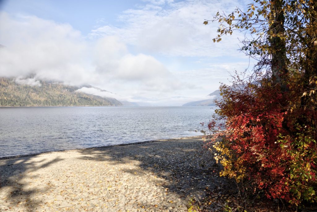 Mabel Lake in autumn.
Mabel Lake
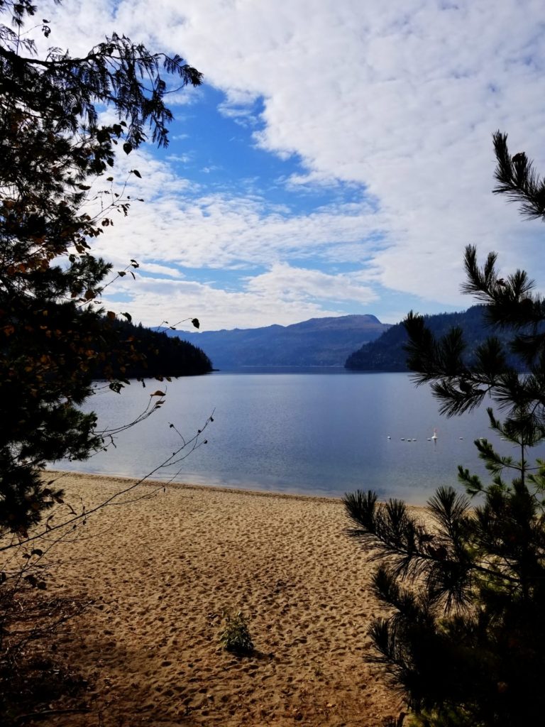
The paved road swings north near Shuswap Falls, climbing away from the river. Near kilometre 35, an opening in the timber provides the first glimpse of the south end of Mabel Lake (and the last glimpse of pavement). Mabel Lake Provincial Park, at kilometre 37.8, is a welcome sight on any summer afternoon. On more than one occasion, we’ve had our choice of sites and were able to camp near the beach and playground. The beach gets the afternoon sun, and the lake’s long, undulating shoreline ensures that it never seems particularly crowded.
A Pioneer Storekeeper & A Pioneer Lumberman
On one particularly beautiful afternoon, after a swim and supper, I settled down to read Grassroots of Lumby: 1877-1927, a hardcover book I acquired earlier at the Lumby information centre. From it, I learned that the surrounding land first belonged to Reginald Sadler, a young Englishman who came to Canada around 1900. T.A. Norris, Lumby’s first schoolteacher, later bought the lakeshore property and lived here for some time before selling it in the 1930s. Will Shields, who spent much of his life as a storekeeper in Lumby, and Henry Sigalet, a pioneer lumberman, bought the property and built comfortable summer homes near the lake.
Born in Ontario in 1884, Shields came to Lumby about 1910 and retired to the Vernon area in 1956. Sigalet was born in Alberta in 1899 and came to the Okanagan Valley two years later. In the midst of the Depression, Sigalet built a lumber mill in nearby Squaw Valley, and in 1940 opened a mill in Lumby. Both Shields and Sigalet died in 1972, not long after completing negotiations on the sale of the property for the Mabel Lake Provincial Park site.
Mabel Lake Provincial Park
The majority of park development took place from 1978 to 1980, but there have been recent additions to facilities. The 84-unit campground has an attractive, 2,100-metre-long shoreline with an excellent beach. The park has a large day-use/picnic area. The lawns are level, open and spacious, providing the opportunity for a variety of games. There are picnic tables among cottonwood trees that separate the lawn from the beach. Hemlock, red cedar and birch shade much of the property, a visible contrast to the sagebrush, bunchgrass and scattered pine nearer to Vernon.
The park is also geared for boaters. There is a double-wide concrete boat launch that slopes gently into the lake, located at the southern boundary of the park beside the South Mabel Marina. There is a large, 60-square-metre wooden dock with rubber bumpers and pilings. Ample parking is available in the gravel parking lot. Ten angled spots for trailers are designated with cement barriers and there are also spaces for trucks with trailers. A turn-around area near the launch makes backing up easier.
There is no phone in the park and the closest store for snacks and other small items is the South Mabel Marina building right next to the boat launch. The marina also has groceries, ice, gas and a great selection of camping and fishing gear. For more services, Lumby is the closest community. Campsite reservations are accepted at this park and first-come, first-served sites are also available.
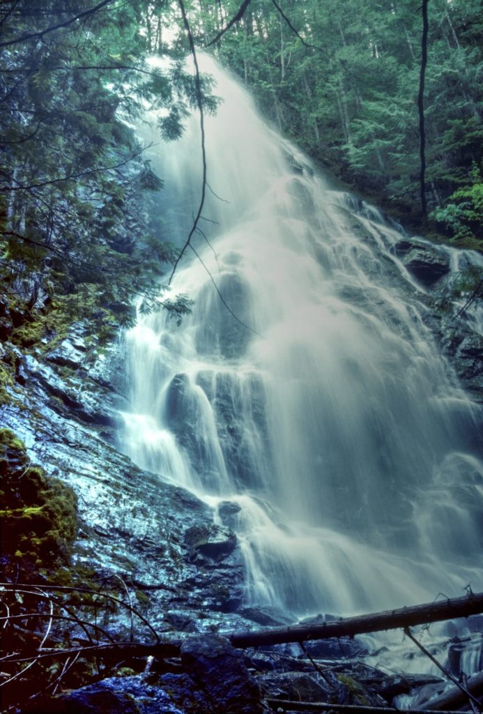 Cascade Falls.
Cascade Falls Trail
The gravel road, now known as Mabel Lake Forest Service Road, winds along the mountainside well above the lake as it continues north of the park. Logging roads offer the occasional diversion, as do roaring creeks. Look for a small parking area on a corner near kilometre 43.0 (about 5.7 kilometres north of the park entrance and just beyond the 15-kilometre marker.) This is the start of the trail to Cascade Falls, which certainly lives up to its name. It resembles an ever-broadening veil as it tumbles down the steep, rocky slope. The 300-metre switchback trail to the foot of the waterfall will require some caution, but otherwise is not difficult.
If you enjoy photography, a tripod and wide-angle lens will help when photographing the falls. A close-up or macro lens will also prove useful for the many fungi, berries and wildflowers along the trail.
 Cottonwood Beach.
Cottonwood Beach Recreation Site
As you continue northward, Torrent Creek, a boulder-strewn waterway near kilometre 51, marks the first return to Mabel Lake since leaving the provincial park. The occasional logging road climbs to the right, away from the main track, but otherwise Mabel Lake Road follows the timbered benches. If the provincial park campground is full, you might want to consider exploring the Cottonwood Beach Recreation Site near kilometre 56.8 (27-kiometre marker). The beach and campground are about 1.5 kilometres off the main road.
The campground has been recently renovated and has 37 campsites dispersed through the trees. Note that a fee is charged during the summer months and that cash is a necessity.
Continuing North
In general, this backroad continues north, except for a loop east to avoid the canyon of Tsuius Creek. If Three Valley Lake is your destination, keep left at the major junctions.
The road climbs high above the lake, offering some spectacular views as it winds through the timber. Then it begins to descend, presenting a last brief glimpse of Mabel Lake through the trees at kilometre 77. Some maps suggest that the old road once crossed Wap River near the north end of the lake. However, the present route to the west side of the lake is still another 10 kilometres to the north.
From the north end of Mabel Lake to the Wap River crossing near kilometre 89, the route varies from a good gravel logging road to a somewhat narrow, lumpy backroad. The barren, boulder-strewn creek beds reveal the terrific force of flash floods that can occur almost any time of the year. The forest roads that veer east off the main road often appear better and more used. This can be deceiving, a point brought home when one ends up in a log landing.
Alternate Route To Enderby
The junction near kilometre 90 (Mabel 59-kilometre marker), a short distance north of the Wap River Bridge, is the first left turn to ignore in your relentless search for Three Valley Lake.
Three Valley Mabel (Kingfisher) Forest Service Road to the left (west) climbs steadily to a high valley, paralleling the west side of Mabel Lake, and then continues south to the Shuswap River outflow of Mabel Lake, then west to Enderby. (We plan to cover the route from Three Valley Lake to Enderby in the next issue of BC Outdoors.)
The road straight ahead again crosses the Wap River near kilometre 93, after traversing a few sandy sections. The road passes under a 500-kilovolt power line a short distance beyond the bridge and swings left through the timber.
It may not be apparent at first, but the gravel road and the Wap Lake West Recreation Site, at kilometre 97, sit on what was once a railway bed. A logging railway, built near the turn of the 19th century, carried timber from as far south as Mabel Lake north to the Canadian Pacific Railway at Three Valley Lake.
Wap Lake is unusual in that the railway bed allows good casting from the shoreline, as well as providing several places to launch a canoe or car-top boat. Camping is limited, with a few spaces at the Forest Service recreation site and a wide spot or two along the road. On one trip, while I tried casting from shore, the rest of the motley crew picked huckleberries and blueberries for dessert. A tasty frying pan upside-down cake compensated for my usual lack of trout reserved for that very same frying pan.
Beyond Wap Lake, the backroad skirts the colourful, lily-dotted marshes and the river, bouncing over several rough sections that could be difficult in spring or after wet weather. This is the section that has occasionally been almost impassable in the past and is most likely to present a problem in the future. The steel-framed bridge across the Wap River, near kilometre 105, is a sign that you have survived the worst and that the rest of the road to the Trans-Canada Highway should be a cinch.
Frog Falls
On one trip to the area, an old sign in a tree just north of the bridge pointed to an overgrown trail leading upstream to Frog Falls. Giant cedar stumps stand like guards at the hidden trail entrance. However, a few hundred metres beyond the bridge, a side road leads into an excellent recreation site and a wider trail to the crest of the falls.
Beyond the Frog Falls Recreation Site, the much-improved road begins a steady descent to Three Valley Lake and the Trans-Canada Highway. After following South Pass Creek and the old logging railway bed, it reaches pavement approximately 110 kilometres from the heart of Lumby. If you are attempting to travel this route southward, look for the Three Valley-Mabel Lake Forest Service Road sign on the south side of Highway 1, near the west end of Three Valley Lake, approximately 21 kilometres west of Revelstoke. Note that some maps show this as Wap Lake FS Road or some variation.
Three Valley Gap
If you’ve had enough of camping and your own cooking, why not stop in at the Three Valley Lake Chateau at the east end of the lake. With hard work and ingenuity, the late Gordon Bell (1933 to 2007) turned an old railway whistle-stop into a fine hotel and unique heritage destination. In addition to the 200-room hotel, restaurant and gift shop, there are numerous restored pioneer buildings and railway cars.
Statistics
Distance: 110 kilometres, Lumby to Highway 1 at Three Valley Lake.
Travel time: Four to five hours minimum.
Condition: Partly paved, some rough gravel sections.
Season: Dry weather; north portion may be closed in winter.
Backroads Mapbook: Thompson Okanagan BC.
Communities: Lumby, Vernon and Revelstoke.
Additional Information
- BC Parks: env.gov.bc.ca/bcparks
- Lumby & District Chamber of Commerce: monasheetourism.com
- Okanagan Shuswap Natural Resource District: https://www.for.gov.bc.ca/dos/
- Three Valley Lake Chateau Ltd.: 3valley.com