
If you are looking for a scenic drive along a mountain lake that hasn’t been dammed, then consider picking up Highway 6 at Nakusp in BC’s Kootenay Country and winding your way south to South Slocan and Highway 3A. Despite the fact that this was the heart of BC’s richest silver mining region in late 1800s and early 1900s, it still has the feel of the backcountry, with more than a touch of history.
Advertisement
While you could do the trip in half a day, allow at least a week if you are looking for a break from the hustle of so-called civilization. Make sure your fishing licence is up to date and your boat doesn’t leak. Fresh batteries for your camera and plenty of space on the memory card will also help, as there will be lots to record.
If you are wondering how to get to Nakusp, you could take Highway 6 over the Monashee Mountains from downtown Vernon – we covered that in Monashee Ramble in the September/October 2017 issue of BC Outdoors. It is a scenic route that could add another day or two to your adventure. You could also drive south from the western outskirts of Revelstoke on Highway 23. Both routes include free ferry rides and plenty of camping opportunities and backroad diversions.
Advertisement
Nakusp & Slocan Railway
The discovery of silver in the Sandon area in 1891 prompted a rush to the Slocan, as BC’s gold rush was waning and Canadian Pacific Railway construction was complete. While gold was a relatively simple metal to separate from the ore, the same couldn’t be said for silver and galena. Smelters were needed to extract the small percentage of silver from the lead sulphide. And smelters required capital and plenty of electricity.
The earliest of the smelters were located on the Columbia River near the American border and in Montana. Transportation was needed to get the heavy ore to the smelters, and paddlewheel steamboats served as part of the transportation equation. Nakusp, on Upper Arrow Lake, was steamboat hub for access to the Columbia River and the CPR at Revelstoke.
Advertisement
The Nakusp & Slocan Railway, constructed in 1894, connected to the waterfront on Upper Arrow Lake on either side of Kuskanax Creek, then looped south to gradually gain altitude before climbing southeast above Box Lake. It continued to climb and remnants of it along the east shore of Summit Lake can be seen from Highway 6. Just past the east end of Summit Lake, the railway began the southeast descent to Slocan Lake, following Bonanza Creek. It followed the east shore of Slocan Lake south to Rosebery, where there was another steamboat dock. It then continued south along the lake, to about three kilometres from New Denver, before it began the steep climb up Carpenter Creek to Three Forks and on to Sandon.
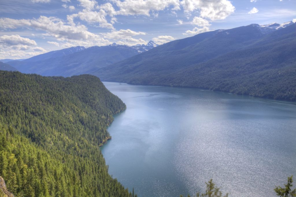 Slocan Lake.
Galena Trail
The tracks were taken up decades ago, but the Galena Trail follows much the same route as the N&S Railway from Rosebery to New Denver and Three Forks. If you brought along your mountain bike, you can access the trail at Rosebery and in New Denver on Denver Siding Road. The upper end is accessible from a wide section of Sandon Road, just off Highway 31A. Look for a path down to Carpenter Creek and a metal footbridge.
The North Slocan Trails Society is involved with the maintenance of the trail, and several others in the area. You can find out more on their website at https://slocantrails.wordpress.com/ or Facebook page at https://www.facebook.com/NorthSlocanTrailsSocietyNewDenverBC/. Trails BC also has information on a wide variety of trails in the province.
Highway 6
The highway follows much the same route as the railway from Nakusp to the east end of Summit Lake before climbing up above the Bonanza Creek valley. There is a private campground at the northwest end of Summit Lake, and a BC provincial park campground less than a kilometre farther along. If you are just interested in getting off the highway, there is a very pretty lakeshore rest area another kilometre past that. Summit Lake Ski and Snowboard Area, near the east end of the lake, has most everything you could want (except giant hotels and exorbitant prices.) Note that they accept cash only. Visit http://skisummitlake.com/ for all the details.
Hills
While there are definitely hills in the area, apparently the name comes from two brothers named Hill that set up a sawmill in the area the 1920s. From 1929 to 1934, several Doukhobor families established farms and a community here. A one-room school followed. When the road to New Denver opened, the students went there and the school became a community hall.
The famous Hills Garlic Festival started in 1993, and a decade later moved to Centennial Park in New Denver. The reason, it is said, was because the Hills community didn’t have a fire department to deal with any spark from the increasing crowds.
New Denver
I touched on New Denver in the Sandon and Idaho Peak article (March/April 2017), but I will add a few more bits of its colourful history here.
Located on the shores of Slocan Lake, many of the homes at New Denver reflect another part of BC’s history, one which has received political and literary prominence in recent years. The oldest, and sometimes grandest, buildings reflect life when silver was king and New Denver was an important paddlewheel steamer stop on Slocan Lake.
To complicate the research of the Silvery Slocan, the village had a couple of names before New Denver stuck. According to Greg Nesteroff of the Nelson Star, one December 1891 news story referred to the community at the foot of Carpenter Creek as Slocan City. It wasn’t long before it was renamed Eldorado and Slocan City became the name for the community farther south at the foot of Slocan Lake. Eldorado didn’t last very long; by July 1892, it appears that the name was officially changed to New Denver. If you are confused, you certainly aren’t the first.
According to Elsie G. Turnbull in Ghost Towns and Drowned Towns of West Kootenay, “The community owed much of its prosperity to the Bosun Mine, 3 miles (5 km) down the lakeshore. Here on a ranch owned by a young Englishman, Joseph C. Harris, a prospector discovered rich ore. Several months’ work paid for a road, wharf, and blacksmith shop, as well as providing funds for a waterworks system in New Denver and the Bosun Opera House.” Turnbull’s book is full of stories of the communities and characters of the region. Fortunately, unlike many books published on the Silvery Slocan, it was still in print at the time of writing.
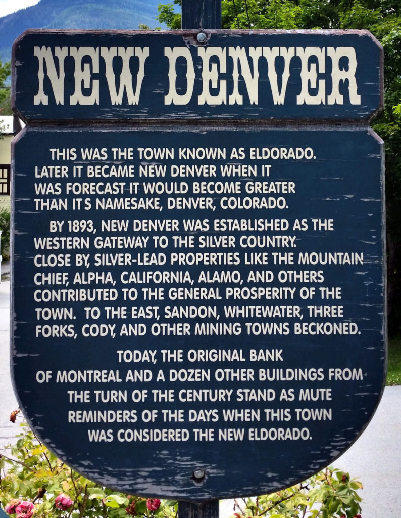 A sign at New Denver tells the story of the town’s previous names.
Historic 6th Avenue
New Denver’s main drag is 6th Avenue. It heads west to the lakeshore from the junction of Highways 6 and 31A. It is the business district, with other important businesses, such as the BC Liquor Store and the post office, on Josephine Street.
Take a stroll down 6th Avenue. The first building on your right (the north side of the avenue) is the new Valhalla Pure Outfitters store. It replaced their original store, located down by the lake front on the corner of Eldorado Avenue and 6th Avenue. The original store opened on Canada Day, 1990. I have a feeling that my wife and I stopped there in the first years it was open. We’ve also stopped at the new New Denver store to replenish our clothing and gear. As Valhalla Pure specializes in summer outdoor clothing and equipment, they are usually closed from late October until early May.
Across the avenue and down a bit is St. Anthony’s Roman Catholic Church, established in 1897. Now referred to as St. Anthony’s Mission, it is served by a pastor residing in Castlegar. Back on the north side and a couple of blocks down is the Silvery Slocan Museum in the century-old former Bank of Montreal building. It is open from the May long week through to Labour Day.
Camping & Nikkei Heritage
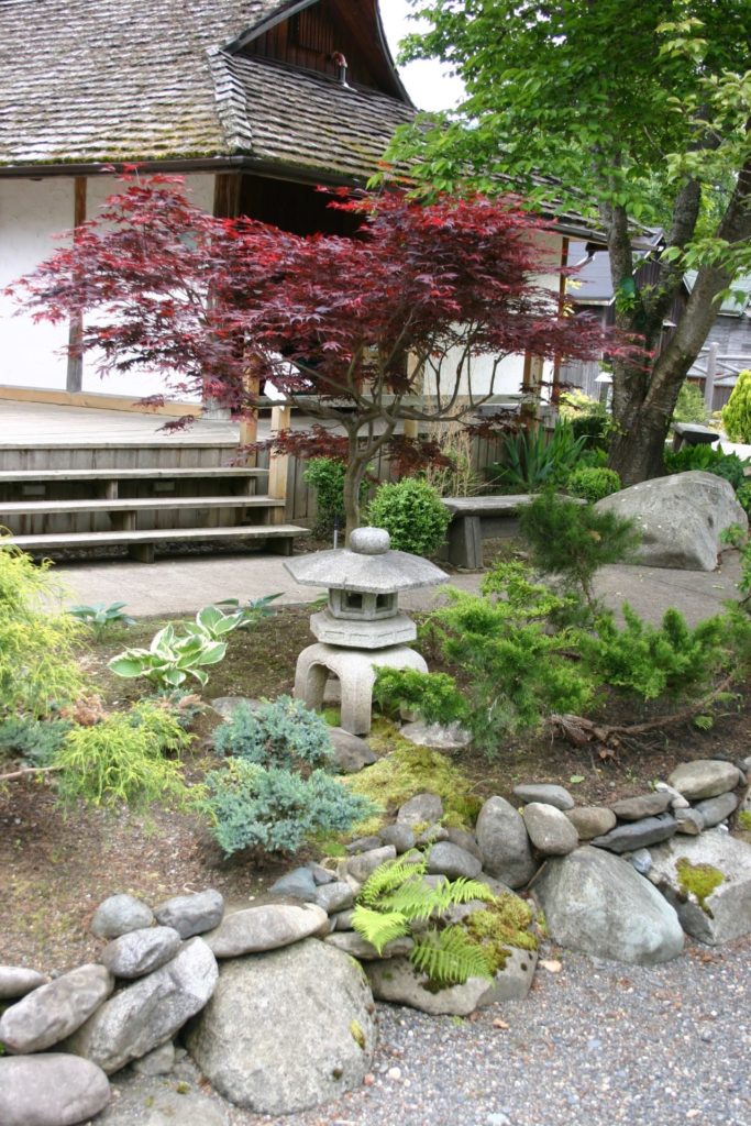
Across Carpenter Creek, on the south side of New Denver, is Centennial Park and it features a campground, sports field, swimming beach and boat launch. The campground can be a busy place in summer, particularly during the Hills Garlic Festival. On the south side of the park is the Japanese-style Kohan Garden. A couple of blocks east, at 306 Josephine St., is the Nikkei Internment Memorial Centre, a National Historic Site commemorating the Japanese-Canadians that were housed here during the Second World War.
 Be sure to visit the Nikkei Internment Memorial Centre while in New Denver.
Valhalla Provincial Park
Directly across Slocan Lake is Valhalla Provincial Park. The 50,060-hectare park extends along most of the lake, from just west of New Denver to Slocan City. In addition to a mountain wilderness, there are numerous beach water-access campsites, including one only a two-kilometre paddle from the New Denver campground. When we last camped at New Denver, our campground neighbours were gone for few days when they paddled their kayaks across the lake.
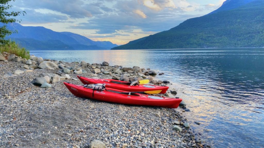 Kayaks stand at the ready on Slocan Lake.
Silverton
The community a few minutes south of New Denver also owes its start to the Silvery Slocan mining boom. The nearby mines supplied the village with prospectors and those who supplied the services. Hotels, general stores, a druggist and a newspaper where among the most notable. Add a wharf to load the rich galena ore onto sternwheel steamers and everything ran full steam ahead. The mining era waned with the end of the First World War, and when the Great Depression was over, Silverton recovered as a new community. Today, Silverton Building Supplies is an important stop, particularly if you are looking for propane for your RV.
Silverton Gallery & Historical Interpretive Centre
Across the highway from the Building Supplies store, the artefacts of the bygone mining boom can give you a glimpse of the hardware used to extract the millions of dollars in silver ore from the mountainsides.
If you are looking for a spot to camp, Silverton has two campgrounds: a small one at Lakeside and another 20-unit site at Creekside. Rates are reasonable, and they have well-equipped washroom facilities. There is also a boat launch located at the foot of Leadville Street, and parking is available for boat trailers and vehicles.
Slocan Lakeshore Drive
If you are interested in a somewhat more unusual camping experience, Bannock Point Recreation Site, approximately 4.5 kilometres south of Silverton, has 10 walk-in campsites spread out along the treed and rocky shores of Slocan Lake. If you have a boat, you can access the campground via the lake about four kilometres south of Silverton.
Highway 6 winds south high above the lake. This no road for speeding or indiscriminate passing, as you could meet a chip truck.
The Cape Horn Bluffs along the highway, approximately five kilometres north of the foot of the lake, were a major challenge to drivers when we first meandered through the area a few decades ago. However, major work in the 1990s opened up a new section of two-lane highway to bypass the narrow section sandwiched between the lake and the cliffs. If you can find a safe point to park, the view up the lake from the north end of the bluffs is spectacular.
Slocan Bluffs
If you are interested in an entirely different view, one with a cliff-hugging perspective, the Slocan Bluffs could be for you. Peak Freaks lists it as one of the most popular climbing areas in the Kootenays. The location is along the old highway, with access from the corner of Slocan Street and Delany Avenue in Slocan City.
Slocan City
Take Giffin Avenue northwest into Slocan (a.k.a. Slocan City) and your next opportunity to camp is about 100 metres down the hill and to your right. Springer Creek RV Park & Campground is another 100 metres off Giffin Avenue. It has a variety of camping options and a trail that leads up to a waterfall. It can be a quiet place to camp, except on the mid-July Slocan Unity Music Festival weekend. The family-oriented festival takes place down on the beach at the foot of the lake, with a broad selection of international and local musicians.
If you are looking for a meal or groceries, Slocan has a variety of choices. The ladies at the Harold St. Café will be happy to serve you breakfast and, if business is slow, bring you up to date on the latest news.
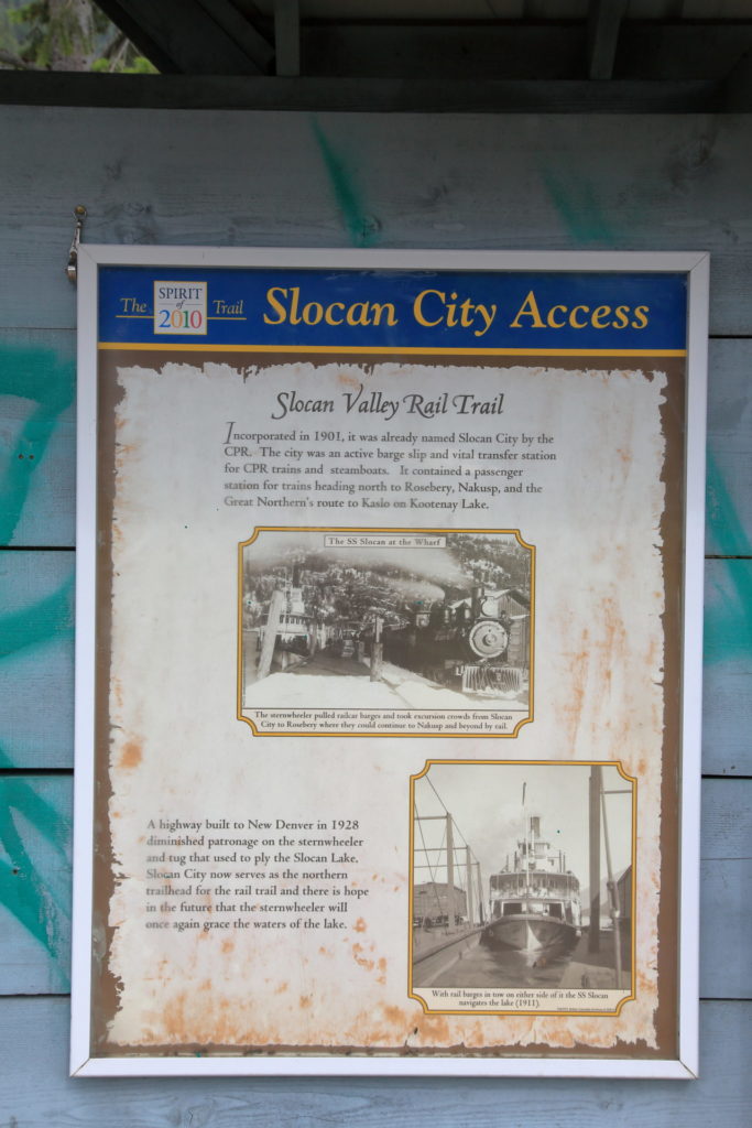
Slocan Valley Rail Trail
It started off in the 1890s as the Columbia and Kootenay Railway, built to carry machinery, supplies and the rich galena ore to and from the CPR mainline at Revelstoke, connecting with steamers and barges on the Arrow Lakes. (You will need a good map to figure out the convoluted route.)
 A sign telling the history of the Slocan Valley Rail Trail. The Slocan Valley Rail Trail Society took over stewardship of the right-of-way in 1994.
Low water and winter ice made the Arrow Lakes unpredictable, and in 1897 the railway was extended to Slocan Lake. Paddlewheel steamers could take the lake to Rosebery, and the Nakusp & Slocan Railway, also a CPR subsidiary, could take the traffic to Nakusp on Upper Arrow Lake.
The line operated for nearly a century before being abandoned and turned over to the Trans Canada Trail Foundation, which in turn transferred ownership to Tourism British Columbia. Several years later, Tourism BC turned over ownership to the provincial government and it is now the responsibility of the Ministry of Forests, Lands and Natural Resource Operations. The Slocan Valley Rail Trail Society took over stewardship of the right-of-way in 1994 and has worked hard to develop a non-motorized, family-oriented, year-around recreational trail.
The 45-kilometre-long trail follows the Slocan River from Slocan to South Slocan, with trailheads and amenities at several communities along the way. Details and maps are available on the Slocan Valley Rail Trail Society website at www.slocanvalleyrailtrail.ca/.
Lemon Creek & Points South
The Lemon Creek Lodge, about eight kilometres south of Slocan, is the next of many opportunities to access services along the busy corridor to South Slocan, whether you are driving Highway 6 or cycling or skiing the rail trail. I won’t attempt to cover what’s available, but check out Appledale, Winlaw, Lebahdo, Passmore, Slocan Park and Crescent Valley on your way south to the junction with Highway 3A, just south of South Slocan.
Your options are many at South Slocan. You can take Highway 3A/6 northeast to Nelson and then continue south on Highway 6 through Ymir to Highway 3 at Salmo. Then you could continue south to Nelway on the US Boundary or east to Creston. At Nelson, you could also continue east on 3A to the junction with Highway 31, with an option to explore Kokanee Glacier Park along the way. Meanwhile, back at South Slocan, you can Take Highway 3A south to Castlegar, where more options abound.
Statistics
Distance: 125 kilometres, Nakusp to South Slocan.
Travel time: Two to three hours.
Elevation change: 325 metres.
Condition: Paved two-lane mountain highway with lots of narrow sections and turns.
Season: Maintained year around. Summit Lake area could get lots of snow in winter.
Map: British Columbia Highway Map.
Backroads mapbook: Kootenay Rockies, BC.
Communities: Nakusp, Hills, New Denver, Silverton, Slocan and South Slocan.