
A line from one of my favorite movies goes, “I never walk into a room I don’t know how to walk out of,” and I’ve always held true to this philosophy whenever I venture off into the bush, both in the military and in civilian life.
Advertisement
A GPS unit or smartphone is almost standard equipment for those who enjoy the outdoors, but the fact is every device which relies on a battery and software can fail. I’ve had not one or two, but three GPS units spontaneously and catastrophically fail in my hands (one of those being a sophisticated Canadian military GPS). These failures didn’t alter my plans, and only resulted in a minor irritation instead of gut-wrenching panic due to my mantra of, “Always have a way out.”
Exit Strategy
A map and compass, along with knowledge and training, will replace a broken GPS unit. The unfortunate fact is that in this modern age, the paper map has been replaced by an LCD screen. This is where a simple exit strategy comes into play and all that is required to formulate one is a few minutes in front of Google Earth.
Advertisement
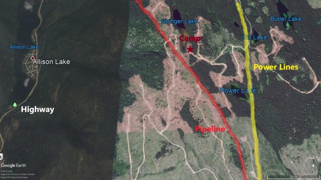 A similar area to my last hunt. I’ve highlighted a pipeline in red and the power lines in yellow.
The first step is to get a good overview of the area where you will be going. Figure out where you will park or camp and where in relation to that point you plan on exploring. Once you’ve determined the where, it’s time to think about the how. This is where I start to look for terrain features to guide my potential egress from the woods.
Figuring out how to walk out of the bush without a map means finding terrain features that are linear, run long enough distances that they can’t be inadvertently bypassed, will be intersected as long as you walk on a cardinal direction (north, east, south or west), and are easy to identify while on the ground. In terms of map and compass navigation, these types of features are referred to as baselines, handrails or backstops.
Advertisement
Man-made features are good choices, as they are in stark contrast with nature and often run for long distances in straight lines. Roads, highways, powerlines or pipelines are good options. Using natural features such as rivers, lakes, ridges or valleys are also viable options, as long as they can positively identified while walking through the bush.
In the example Google Earth image, we can see that there is a highway running north/south, power lines running north/south (highlighted in yellow) and a pipeline cutting diagonally across the terrain (highlighted in red). In this example, let’s assume that camp is at the rec site on Stringer Lake and the hunting area is to the south. Since the pipeline passes right by the lake, it seems to make a good terrain feature to utilize; however, there is a sizable gap between the highway and the pipeline that one could walk right on through, missing the pipeline completely. Walking west to the highway or east to the power lines are the best options. Walking east to the power lines requires one to turn left and walk north until a forestry service road intersects it, then another left to walk along the forestry service road back to Stringer lake.
On a recent hunt in a similar area, my hunting partner and I decided to make camp at a lake adjacent to power lines that ran north/south. We knew that if we were hunting southwest of camp, all we needed to do was walk east to the power lines, hang a left and walk back to camp. Since I always had a compass in my pocket, I was never concerned with not finding my way back to camp.
It is very important to write down your planned route as to not forget key details, and above all else keep it as simple as possible.
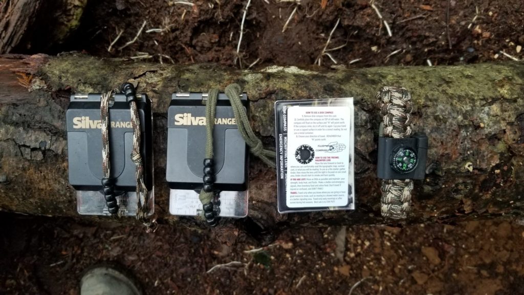 This is my bare minimum must-haves: one compass in my pack, one in my pocket or binocular harness, a Brunton floating disc compass in my binocular harness and a button compass on my paracord bracelet. Not shown is the magnetized needle I have taped to the back of my belt knife sheath as a last resort.
Have Compass Will Travel
A compass is useful even without a map because it enables you to accurately shoot a bearing, making walking in a straight line actually possible.
Button compasses are a good backup to a good sighting compass, but I have found that it is important to check their accuracy before trusting them. Their size makes it tricky to ensure it is held level, which is why I make a habit of gently rocking button compasses in all directions until I’m satisfied that the compass is level and has found north.
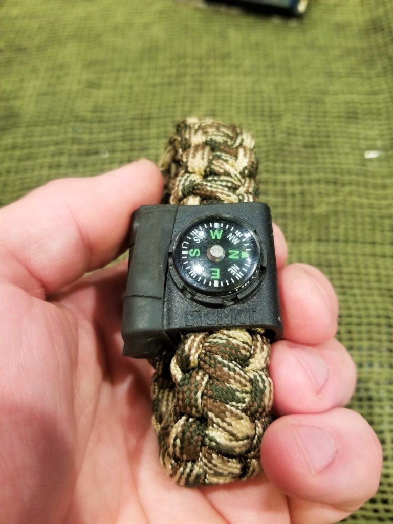 A button compass is a good back up, as long as you make sure to hold it level.
If you have a compass and a direction of travel, all that is needed is to start walking without veering off course. The issue is that human beings have a natural lateral drift that leads us to walk in large circles, which is why a compass is so indispensable.
With a sighting compass, walking a straight line is as simple as dialing in your desired direction of travel into the compass using the bezel and shooting a bearing to an object to walk to. Once you’ve dialed a bearing into the compass, tilt the mirror so you can see the face of the compass in it, then bring it up to eye level. Turn your body around until you can see the red needle inside the hollow red arrow on the baseplate. Using the sighting notch, find an object in the distance and walk to it. Repeat the process until you reach the destination.
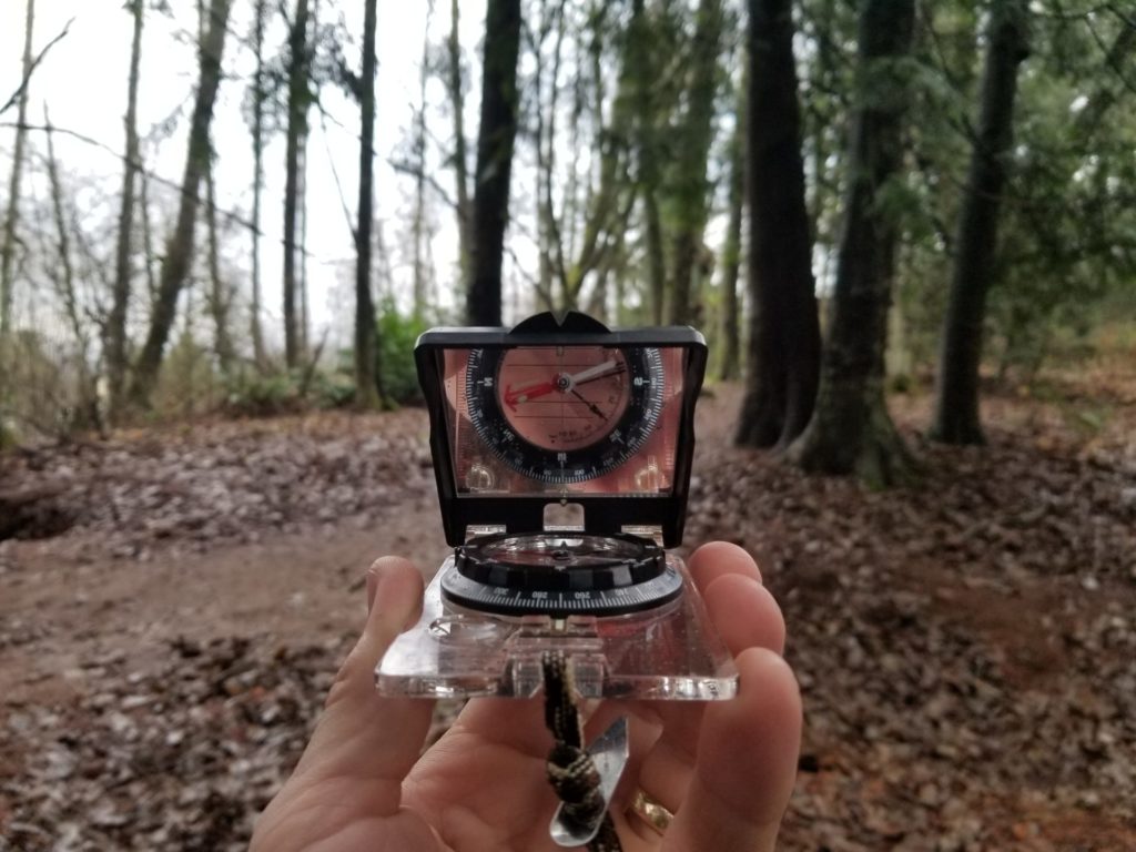 Using a sighting compass, as shown, is the most accurate way to navigate along your chosen direction. Note how the face of the compass is visible in the sighting mirror.
A button compass can be used in the same manner; however, there will be no bezel to turn so you will turn around until the desired direction is pointing directly ahead. Pick an object to walk to and get moving.
The Sun & The Stars Guide Us
The sun will always rise generally east and set generally west, but around the summer solstice it will rise northeast and southeast around the winter solstice. During the zenith hours (between 10 a.m. and 2 p.m.) the sun will be overhead and to the south.
In 15 minutes, with an approximately two-foot-long stick and two stones on a sunny day, you can make a primitive compass. Jam the stick into the ground and it will cast a shadow; at the end of this shadow, place one stone this is the west mark. Wait 15 minutes and the shadow will have moved, now place a second stone at the end of this shadow, which is the east mark. A line drawn between these stones indicates an approximate east/west line and from here it is easy to deduce north/south.
At night we can use the stars to guide us. The north star is only about one degree off true north, and the further north you travel the higher in the sky it becomes. At about 70 degrees latitude, the north star becomes too high in the sky to be useful. A point of note is that the north star is not, in fact, the brightest star in the sky, it is the 50th brightest, which means we need help to find it.
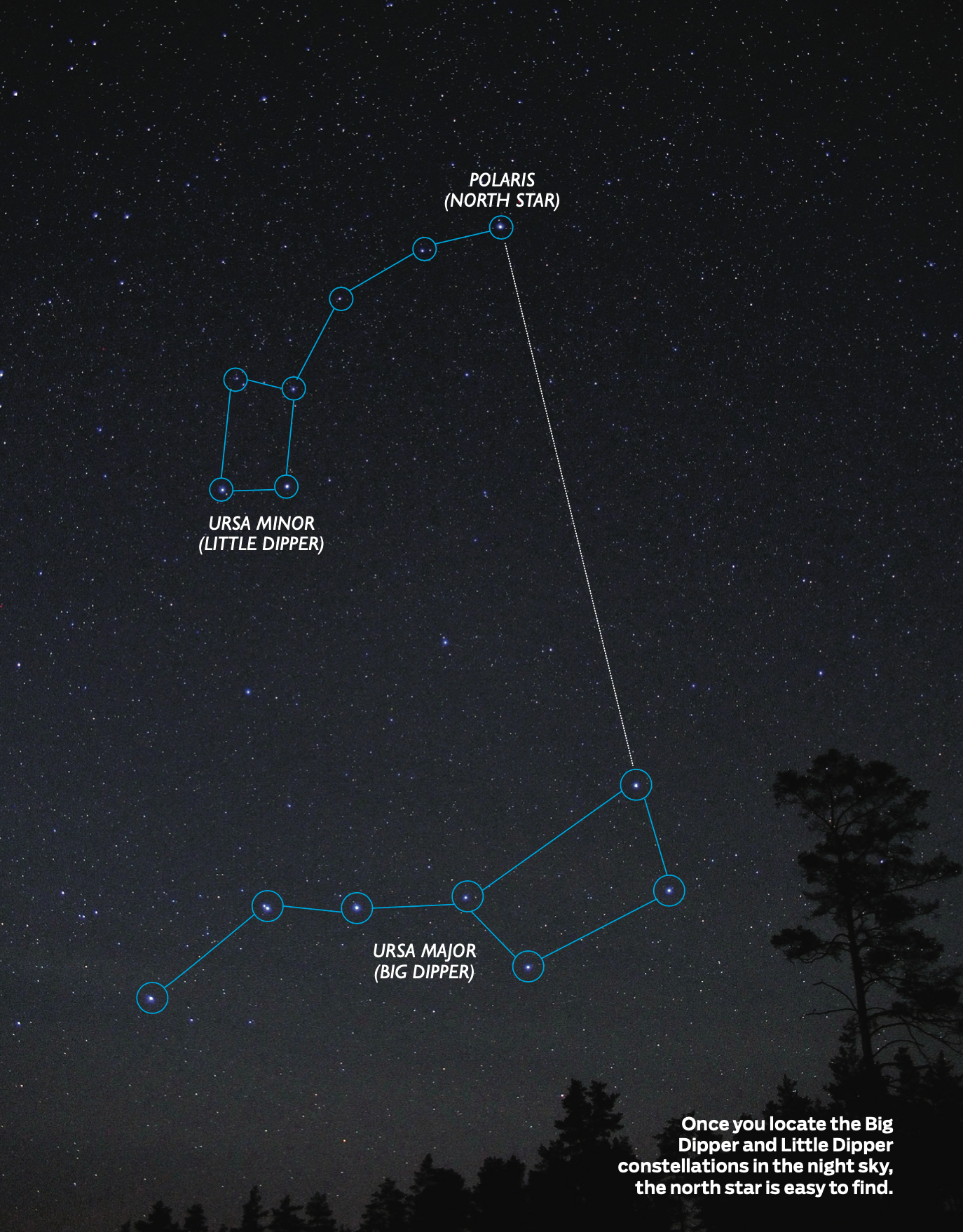 Photo by Dreamstime/Vitalij Kopa.
The Big Dipper is one of the most recognizable constellations in the night sky, which never sets for us in Canada. The outermost two stars of the bowl are the pointer stars that guide us to the north star. Visualize a line projecting through these points and they will intersect the north star, which is the last star in the handle of the constellation known as the Little Dipper. The constellation of Cassiopeia is a good double check, as it is directly opposite of the Big Dipper, with the north star in between them. Cassiopeia is recognizable because it looks like a ‘W.’
Walk The Line
Without a compass, walking a given direction without ending up travelling in circles is difficult. One method is to use the position of the sun to orient ourselves while on the move. For example, if travelling west in the morning, the sun will be to our backs and as it reaches the highest point in the sky it will be to the left. The opposite is true of traveling east. Northward travel will have the sun to the right in the morning and to the rear at midday, again the opposite is true of southward travel. If you remember the basics of how the sun moves across the sky, you will be able to deduce where it should be in relation to your direction of travel.
Without the sun, walking a straight line requires at least three reference points: where you are, where you are walking to, and a point directly behind. As you walk, the key is to be able to identify and line up all three points as you move forward. In dense timber, blazing trees by cutting a strip of bark off with an axe is a good and quick method to create reference points.
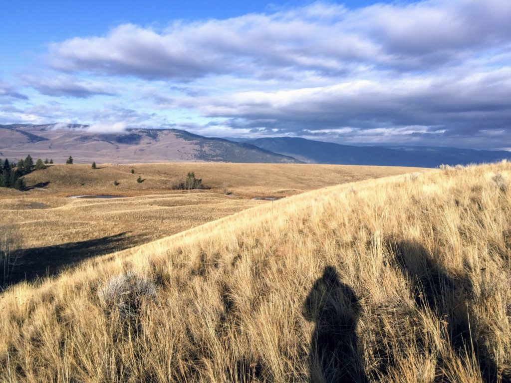 If you remember the basics of how the sun moves across the sky, you will be able to deduce where it should be in relation to your direction of travel. Photo by Sylvia Dekker.
Final Thoughts
Stuff happens, so at the minimum carry two compasses and know your exit strategy. Better yet, carry a map and learn how to read and navigate by it so you’ll always know where you are. No matter how proficient one is in map and compass navigation though, there is never a situation where a solid but simple exit strategy isn’t required.